Our project at the Rectory has been on-going for the last 4 years. Our original aim was to try and locate the old Frog Lane, which became buried under landscaping when the present Hall was constructed. However we are also hoping to discover earlier features, such as a Medieval moat, which is reputed to have surrounded the site in the 15th century.
The Rectory belongs to Wigan’s All Saint’s Parish Church which dates at least to the 11th century – it’s thought to be the ‘Church of the Manor’ mentioned in the Doomsday book. (The current church is an 1840’s rebuilt but the tower and side chapels are original.)
We also know that there has been Rectors of Wigan since the late 12th century. These Rectors were also the Lords of the Manor which suggests that the Rectory was also the Manor House for Wigan. We have every reason to suppose that it was located on the current Rectory site.
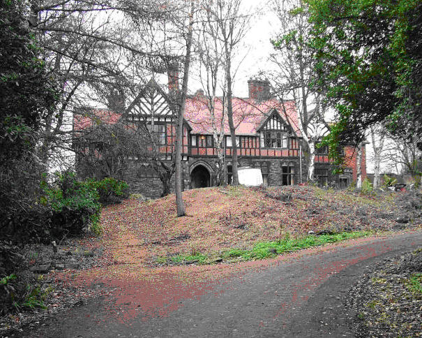
The current Hall sits on a low hill at the bottom of Hallgate which is a road linking it to the Church. This current building was constructed in 1875 by Orlando Bridgeman who was the Rector at the time. It was his researches into the history of the Parish Church which revealed that the Rectory site was once had a moat with a gatehouse and even drawbridge – these features are not now visible and do not appear any maps.
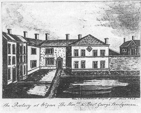
Our only image of any previous building on this site is a drawing dating from 1826 – which we know was built in 1695 from the date-stone which is now built into the cable end of the current building. We also know that it was built more or less on the same site as the current Hall however subsidence due to mining made it unsafe and it had to be pulled down.
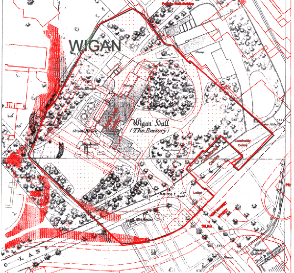
The first accurate maps of Wigan date from the early 19th century. This 5ft OS Map from 1847 shows the previous Hall with the current extent of the grounds overlaid in red. (The Hall is now surrounded on two sides by the Deanery to the west and Wigan College to the east.) We can see quite clearly that the old Frog Lane used to run well inside the current boundary. (Using overlays we were able to select the best area for our excavations.)
Our first site, which we called Area 1, is located on the left hand side of the entrance where the old Frog Lane began to turn into Hallgate (here is a detailed blog of our activities there). Most of the excavations on this site were completed at the end of 2010 but we have returned here earlier in 2012 to investigate some unanswered questions form our initial work (here is a detailed blog of our most recent activities there). We have also investigate another site called Area 4 in the far right hand corner where we hoped to discover evidence of a back entrance to the Hall (here is a detailed blog of our activities there).

Dear Team,
Thanks for your fascinating work at the Rectory. I’m doing a spot of research myself concerning old Hallgate. I’m trying to find a former house called Crosses on the Hallgate, which was a burgage and owned by the Lord of the Manor, which was the Rector. This house still existed in the 19th century. I wonder whether it exists on an old map or in some records. If you have any information on this, please let me know.
Many thanks,
Paul James-Griffiths
Hi Paul – this sounds like a pub but i can’t find a reference to one with that name on Hallgate. I will forward you a couple of early maps of the area which may have your house on (you will see, however, that burgage plots had gone by the early 19th century in the Hallgate area).
Bill
Saw an article in Wigan Observer I am really interested in your project as did not know it was there, even though I have lived in Wigan all my life. Can you recommend a book I can buy to delve into this fascinating project, I would like to learn more re my local history.
Hi Donna,
We haven’t finished the report on our work there yet but if you want to learn more about the history of the site then a good start would be ‘The History of the Church and Manor of Wigan’ by GTO Bridgeman (1888). There may be a copy in the Library under local history, but if not, you should be able to see a copy up stairs in the Wigan Museum.
Thanks for the intresting info and updates.
very intresting read about the moat. What are your future plans for the site?
All work finished there last year when the site was sold. We haven’t been able to arrange anything with the new owner but we suspect it may be difficult as it would hold up any development he has in mind. Already plans have been passed and work has started on a new entrance which happens goes through one of the areas (Area 1 Trench 2) we investigated. Fortunately that particular trench was empty. I would hope that any future planning application for work in the grounds would have an archaeological condition place on it, particularly if it was in an archaeologically sensitive area. I’m guessing his main focus at the moment will be on the hall itself.
Hi guys, having read through your excavation notes it seems very plausible that the trenches you decided to test were following the path of a tiered drainage trench (especially with the field drain pipes that you found), built to stop the old Frog Lane path from flooding. This seems very likely given that the old road was only dirt on clay, and being at that time one of the main routes in and out of Wigan and the main route for the rector and his entourage to and from the Rectory to the Parish Church. Being also the Lord Mayor it would have been easy for the Rector to get manpower to build this drain. The finding of broken pottery and building rubble suggest the drain was not only built once to serve the route, but was reopened and reinforced at a later date ( probrably when the Rectory – Wigan Hall was rebuilt). This would explain the cinders which were part of the original building.
Hi Geoff, your proposition is quite reasonable and it’s what we originally assumed. However what’s baffling is that the large trench on the north side, is much too deep for a water drainage. The cast iron pipe we found in the bottom, strangely terminated abruptly just as it appeared from under the concrete slab. Either it wasn’t finished or it was taken out at some point in time before the field drain was put in. There is a similar mystery with the cast iron pipe in the trench on the south side of the road (we suspect this could be a gas pipe). It’s a shame we couldn’t find the moat but with a bit of luck we may get another chance in the near future.
I used to live at the back of the Rectory in Park Crescent. There has always been a stream running over Bull Hey Cricket Ground. It was drained with field pipes many years ago by the groundsman Bill Layland because the water was coming from Parsons Walk from the park pond across where the bungalows are built now. The council put an extra drain in at No 19 Parsons Walk.This area has always been troubled by water. Barley Brook was diverted by the railway embankment. Perhaps these may be some clues about moats and water.
Hi – you could well be right, some people think the water course separating the Hall grounds form the Cricket Ground was the reputed moat. I’m not so sure as the reports describe it as having a drawbridge and gatehouse which would indicate something bigger that the water course shown on the maps.
I only know the amount of water that was about 100 years ago and was evident in 1942. There was a pond in the middle of the sheep field where The Thomas Linaker school was built,a pond nearer the railway embankment between the All Saints School and the Cricket field and the water which drained across Parsons Walk
onto the Cricket Field at Bull Hey.The school playing field was made at the bottom of the slope from the Rectory.There has been a lot of movement all around that area what with the railway embankment and the Mesnes colliery where the crickett ground was made.
There was a lot of low lying land to the north of the Rectory but as you say there has been a lot of re-landscape so perhaps may never know the true story.
Hi. Yes the water problem is no doubt from the park duck pond one of the mesnes pits was located at the side of the duck pond in 1840 the other two pits across the road on bull hey field. now the cricket ground.