<<<Back |
Further Haigh Hall |
Q
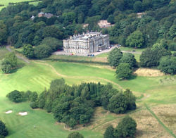
While I accept the house was in the same location, depending on the planimetric accuracy of the 1796 Map and the topography, I think the footprint of the house was slightly north-west. I still contend the terrace and cutaway slope behind the house is 19th century. References to older cellars found would have to be near the west frontage, as what is likely to have happened is that the previous house was build on a smaller platform into the slope; the present house is built deeper into the slope on the east side. The west front is located at the outcrop of the pre-existing slope, anywhere further back has been excavated from the slope to an increasing degree eastwards. The 1796 Map shows exactly the same layout as the Knyffe & Kip view of 1707. Both the map and the view suggest the house was standing on the general slope, not the massive terrace with backslope. Again that favours a slightly north-west of present location. Regarding claims that the garden design in 1707 never actually existed, the copy quality of the 1796 map sent to me ...shows all the detail. This point is picked up in the archaeology report page 5. Returning to my observed earthworks in the angle of School Lane and Copperas Lane I would still appreciate someone following up on this. Several points might justify this. The three fields west of the hall, Senntour Hall Croft, Great Hall Croft and Hall Croft, while they relate to the hall on the east, relate to my earthworks on the north. The shape of Long Stone Low (or Land) on the east side of School Lane, which contains my earthworks was an unusual shape on the 1796 map, having a curved long profile and extending east of a linear boundary at Haigh School. On the small scale Getmapping air photo, there is a distinctive ridge or bank corresponding to this curved north boundary. I wondered if this could be part of the boundary of something larger, such as a deer park boundary, or a pre-medieval defensive enclosure. The name Long Stone Low and Rough Stone Low/Green Stone Low to north may be a reference to older remains here. I cannot make out clearly the name of the third west Hall Field but it looks like Senntour. Maybe there is a documented explanation for this name. I just wondered if the second syllable 'tour' refers to tower, and the other half Senn is sean - old or ancient. So although the earthworks I noted don't relate to the 18th century house, they might still be indicative of an earlier site. Thanks for bearing with my ramblings. |
AI haven't seen the 1796 plan that you speak of but my doubts about the validity of the 1707 view of the Hall and formal gardens, stem from some of the features it depicts. The main access road, for instance, is shown entering from the southwest to join the road leading to the southeast entrance of the Hall at a small distance from it. This looks to be a substantial road which surely would have survived in on form or another, but there has never been any sign of an entrance to the Hall from this direction (even before the landscaping for the golf course). I have also been looking at Donald Anderson's book "Life and Times at Haigh Hall" in which he describes in some detail the build and repair work carried on at the Hall over the centuries. There are 3 colour plates, a B & W print of a portrait painting and sketch all showing the Hall in its condition before the 19th century major rebuild. None of these match the view given on the 1707 which shows the Hall having three bays facing the formal garden. The southeast facia is also totally different. Reading the detail however, the Hall apparently had a partial rebuild in the 18th century after damage from mining subsidence. This gave it a brick frontage on that side. Later when the Earl came to do repairs in the early 19th century he noticed that the walling on the southeast face butted up to the southwest face. This suggests that this side originally extended much further, which could explain the 3rd bays shown on the 1707 view. I agree with your observation that the Hall platform has been substantially increased. The paintings tend to confirm this but whether its position has shifted is unclear, but it does seem that the Hall lost a substantial section on the southeast side at some time. The only view showing anything of the formal garden is the B & W portrait painting which shows the 4th Baronet with his wife and dog. The Hall in the background and the painting also shows terracing, walls and even a boating lake. There is reason to believe that this painting is accurate as detail of the old build behind the Hall matches the detail on a later painting (an elevated bay supported on two pillars). I am coming to the conclusion therefore that the garden did exist in some form but has been totally destroyed by later landscaping. I have not had chance to view the features you describe behind School Lane, but as soon as I have I will get back to you. By the way, there may be some significance in the lane (Sennicar Lane) which runs down from School Lane to the River Douglas. |
<<<Back |