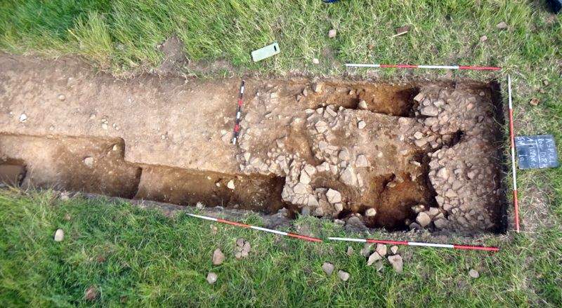
It seems at last we are beginning to understand the nature our ring ditch monument at Aspull. As mention in our last Newsletter, the intention this year is to focus on the interior where a shallow mound seems to cover the whole internal area. We started in Trench 8 but this work had to be abandoned as the natural ground surface was being difficult to identify (crucial if we are to understand the mound's structure). We have therefore transferred out attention to Trench 1 where the stratigraphy is much clearer. The ditch here can clearly be seen cutting into a glacial deposit of compacted stony clay, lying on top of the bedrock which has also been cut into. Lying between the ditch fill and the plough soil is a deep layer of subsoil. As we move away from the ditch, the subsoil gives way to a thick layer of soft, orange coloured, sandy clay. This lies on top of the hard stony natural which we can chase towards the centre. It was this trench therefore that we got Nick the farmer to extend, which he did by taking the top soil off by a further 6 metres towards the centre. At first, we weren't sure how far to go but the last 2 metres or so had become very stony and so this is where we stopped. As we cleaned up this area, it was clear this was a substantial area of stones. At the very end of the trench the stones became much more consolidated, suggesting this was perhaps the edge of a central cairn. Further excavations have revealed however this stonework is lying on top of the soft sandy clay that covers the general area. Still, the stones are a well-defined feature, but what they actually represent, has yet to be determined. A lot will depend on establishing the underlying natural surface, but once again this is proving difficult. The original ground surface is obvious in the area around the ditch, but as we move towards the stony patch, a specific dividing line between the upper soft layer and lower hard surface becomes unclear. Further work will hopefully resolve the issue.
Moasure ONE
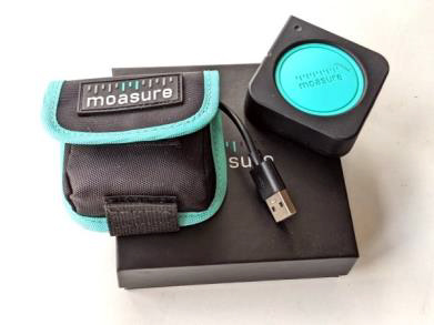
This is a new measuring device that we have been trialling in the last few weeks. Recording of our archaeological features usually involves using string lines, spirit levels, tapes, plumb bob etc., - always very tedious, time consuming and needs two people. Information is gathered on paper, which then has to be transferred into our digital drawing, which again takes time. We've looked at other methods such as the LiDAR function on the iPhone which can produce a 3D model of our structures, but the resolution is less than sufficient for our reports. We have a laser measuring device which we used successfully on our survey of the Parish Church, but it isn't practical for measuring outdoor trench sections. A Total Station or GPS would be great but well outside our budget. This new device, however, is within our price range and, as it depends solely on its movement, has no need for tapes or strings. All measurements are logged and stored in 3D CAD format which can easily be uploaded into the drawing system. We are gradually getting the hang of using it (accuracy depends on careful handling) and our trials in the field have so far on the whole been positive. You can learn more about our progress as usual on our blog diary here.
Summer Trip
Nothing has been arranged for this yet. Fuel cost still remains an issue, so we're not looking at a long distant trip. We usually like to visit an active excavation, so one suggestion has been for an open day at out site in Aspull. For keen members this could be combined with a trip to see our nearest prehistoric sites up on Anglezarke moor and Winter Hill. Sites such as the early Neolithic Pikestones long barrow and Bronze Age Noon Hill are relatively easy to reach. The enigmatic tumulus of Round Loaf, which you can actually see from our site, is more difficult to get at but rewarding nonetheless - suggestions to be discussed at the meeting.
Next Meeting
Wednesday 5th July - at the Real Crafty on Upper Dicconson Street starting at 7.30pm as usual. In last year's March Newsletter 249, I reported on Jonathan Starkey from Buckinghamshire's suggestion that the famous battle of Brunanburh was fought on the banks of the River Douglas near Wigan Pier. Who's to know if his speculations are true or not as his claim maybe just as valid as anyone else's. There is just so little to go on, with the result that there is any number of other claimants for the site. At our next meeting, Dave Hampson from the Wyre Archaeology group will be giving his take on the event and possible locations. It's a fascinating story so hope you can make it.
|