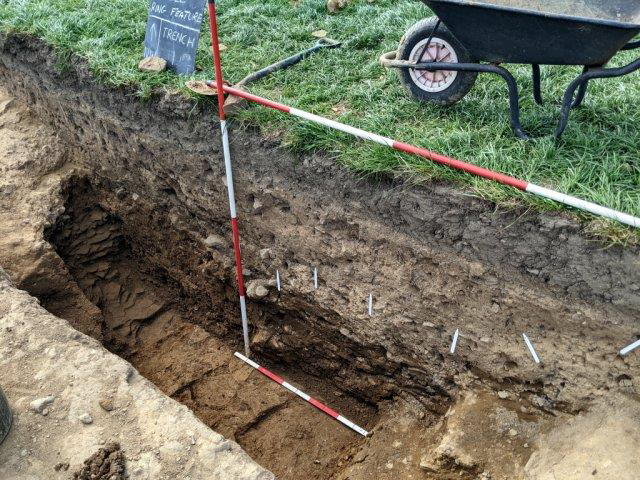
It took just a couple of weeks and seven visits to confirm that the feature, which we'd seen on aerial photos, is actually a ditch - and it's a big one. It measures over 3m wide and 1.5m deep and is bigger than any I've seen associated with this type of monument. We are assuming at the moment it's a Bronze Age round barrow but without dateable finds, this has yet to be confirmed. It is also unusual in that the ditch has near vertical sides with a flat bottom this shape is know for features of this type. It does however represent a huge amount of effort by whoever constructed it. The compacted clay it's cut through is tough and the bottom half of the ditch has been excavated into the bedrock. Our trench was positioned using information from last year's resistivity survey (see Newsletter 246) as it coincided with the crop marks on the aerial photos.
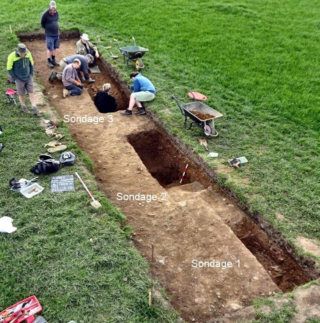
This proved to be quite accurate as, when the farmer used his machine to remove the topsoil, a distinct change in colour of sub-soil was detected almost just where the survey had predicted. The 11m x 2.2m strip provided enough room for us to excavate the feature and, starting with test pits (know as sondages), we began to explore the stratigraphy. Our first sondage, located outside the feature, revealed compacted clay with a pinkish tinge and about 15cm below that we hit the bedrock. We assumed these two to be the natural substrate. Our next sondage was placed across the change in colour of the sub-soil and immediately hit on the fill of the ditch. We located our third sondage further inside the ring feature, but with no obvious colour change, this had to be extended and deepened before the inner edge of the feature could be detected. Eventually the two sondages were joined up so that the full width and depth of the ditch could be exposed. As mentioned, there were no finds but at least one re-cut could be seen in the section. Also, dark staining in the soft clay fill, could be a layer of burning as it had inclusions of charcoal. Samples have been taken from this in the hope of obtaining dating evidence.
A final sondage was dug on the inside of the ring, to see if we could identify the mound seen on the LiDAR image. Once again we came across the pinkish tinge of the compacted clay. However, this lay under a thick layer of soft sandy clay, which got thicker moving towards the ring's centre. This we assume to be the bank of the mound. In the next phase we will be exploring the centre of the mound with the hope of obtain more dating evidence. Before we finished this first phase however, we asked the farmer to remove the topsoil from another location on the west side of the ring. This was to see if we could identify the feature in this area and thus get an accurate size of the monument. So far this has proved to be unsuccessful, but it is early days. You can see the full story on our blog site here.
Hurst Grange Dig
The Friends of Hurst Grange are planning to excavate the site of the old 19th manor house this weekend (6th May). In March we carried out a resistivity survey for the Friends (as reported in last month's Newsletter 250). The survey was successful and now they want to see if they can expose its remains. The excavation is planned to last for 3 day and interested volunteers can contact them on info@southribble.gov.uk (there's also more details on Facebook).
Burscough
A new season of digging is planned for this summer and this time it will be on the fort site itself. The incursion by his neighbour in 2019 means that Steve Baldwin will be investigating this area, assessing the damage caused by the excavator. More details are on the Friends website and Facebook pages.
Next Meeting
Wednesday 4th May - in our new venue, the Real Crafty on Upper Dicconson Street (7.30pm as usual). Ollie Cook from Salford Archaeology is our speaker this month. Late last year he headed a team excavating a site just north of Leyland. Lower Farrington Hall was a moated manor house dating from the late Medieval period. It was later converted into a farm and the moat filled in. Ollie's excavation revealed the moat in the area of its bridge which is in a marvellous state of preservation. It seems timbers from the original Hall were used in its construction. It sounds like a fascinating project - sure to be a great talk. Hope to see you there B.A.
|