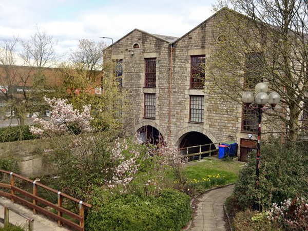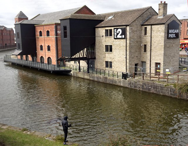
Last summer (Newsletter No.234) I reported on the Council's regeneration project for the Wigan Pier Quarter, which is now complete and is just awaiting the end of lockdown. This renewed interest however has highlighted the fact that the history of many of the buildings around the basin has not been properly understood. For instance the Terminal Building is listed and credited as being built in 1777. However it doesn't appear on a canal survey map of 1802 and is more likely to date from 1827. Meanwhile the nearby (No2) Warehouse isn't listed but is on the early map and documents show that it probably dates from 1774. Neil Linford has therefore proposed a project to try to iron out these issues, to indentify other buildings around the canal basin which have historical value and research their true history. The intention is for it to be another collaborative effort with the WLHHS, similar to the Kings Street HAZ project, as we can use our Town Centre Survey database for collecting the data. The project will also be getting help from canal historian Mike Clarke and Bill Froggatt from the Canal & River Trust.
A particular contentious issue is the origin of the basin itself. Derek Winstanley and I first looked into this six years ago as part of research into the history of Wigan Pier (which was the subject of his WLHHS talk last month - now available on YouTube). At the time, Mike Clarke had presented the previously mentioned 1802 canal survey map to us which shows two channels branching from the river towards the current basin. These were not connected to the basin and our conclusion was that these two legs represented the remnant of the terminal dock of the Douglas Navigation which was complete in 1741 (click here for the map and relevant report extract from).

Mike Clarke however has always been of the opinion that the current basin was the original dock, becoming part of the Leeds & Liverpool Canal when it reached Wigan in 1781. We struggled to imagine this as the canal is much higher than the river at this point and we couldn't see any evidence of another channel leading from the river to the basin as suggested by Mike. Since then, as result of our Douglas River Project, more information has come to light which suggests that Mike's theory might actually be correct. We were looking at the Navigation's river locks (on his website Mike counts 13 in all). We had more or less located them all except the first one out called Harrison Platt lock. It's described as being on the end of a man-made section from the terminal basin. On the 1849 OS map, Harrisons Meadow Chemical Works is shown located behind what is now B&Q on the Robin Park estate on the west bank of the Douglas. This seemed to be the obvious place for the lock. If true, it seems logical that the canal, as it is now, follows the route of the channel that Mike refers to into Wigan - and, therefore, the current basin was also the Navigation terminus. More research is needed as there is a huge difference in height at this point but other documents seem to support the theory suggesting that there was a double lock here. There is also some sense in it, as a direct route into Wallgate would certainly avoid the torturous journey around Adam Bridge (and avoid the need for a weir on the river in an area notorious for its flooding issues).
The river and later canal basin wasn't just used for exporting coal; the area became heavily industrialised, starting 18th century with pottery and pewter works and iron foundries, followed by cotton manufacturing in the 19th and early 20th centuries. Huge factory complexes sprung up such as Eckersley's, Trencherfield and Victory Mills. The latter has more or less disappeared and Eckersley's is in a very sorry state but Trencherfield has been saved by converting it into modern apartments. In 2006 excavations were carried here by Oxford Archaeology North who discovered evidence of the earliest Trencherfield Mill dating from 1823 (there were 3 in all side by side). They also excavated the Blacking Mill site on Pottery Road opposite the Terminal Building (Newsletter No.92). The 1802 map has also revealed that this was originally the site of Bolton's Iron Foundry and Pewter works dating from the 18th century.
Our project will hopefully unravel the stories behind all these building highlighting their historical importance. We have already had a Zoom meeting of interested parties and a way forward has been established.
Next Meeting
Still no meetings for us yet but the WLHHS will be holding their meeting via Zoom on Monday 12th April at 7.00pm. This will be a talk on "The Barbarous Murder of Wigan Lane" by our very own Jim Meehan - a story of Victorian Crime and Punishment. You can attend this meeting free of charge by contacting Clare Kenyon on MarieClareC@msn.com.
Keep safe - BA
|


