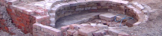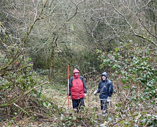
This weekend, at short notice, we managed to arrange a field trip to our Pingot site near Lamberhead Green (apologies to those I didn't manage to contact). We had planned to do this visit at the end of last year but an opportunity never seemed to present itself. Our June Newsletter (No. 174), set out our aims here, which was to find evidence for the Arches viaduct. This structure once carried the Clarkes wagon road over the Pingot valley and was taken down some time in the late 19th century. Our previous survey had enabled us to produce an accurate drawing which we could combine with the old maps. From this we have been able to predict the likely position of the structure's piers. However our visit in May last year, proved that effective work here could only be achieved when the vegetation was low (i.e. Autumn or early Spring).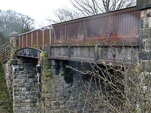
With time running out this year, we were determined to press on with this project, despite the predicted bad weather. The rain however couldn't dampen our enthusiasm, as we could see that the reduced vegetation would give us the best chance of acquiring our sightlines through the undergrowth. It still took a certain amount of pruning before we managed to get a line of ranging poles on the predicted alignment. By studying the maps we could see that the best place to look for surviving pier footings would be at the south end near to the current railway line, as there didn't seem to be any later development in this area. After some more selective pruning, we could detect a low mound at the right location. Probing showed that there was something at about a spade's depth. However we realised that only an excavation could settle the matter. The land is owned by Tim Bankes who also owns the Winstanley estate but it is not certain whether he would give his permission.
Whilst on site we decided to have a look at the foot bridge over the railway which is locate behind Duke's Barn, the farm next to the current road bridge. According to Donald Anderson, it was originally part of the viaduct, constructed in 1848 when the Liverpool Bury line was put through. When the viaduct was taken down the bridge was relocated onto its current site. It's constructed of cast iron, including the parapet, and shows two spans, although it is thought that only the span nearest the camera was used for the viaduct.
Artefacts and Monuments Record
In last month's newsletter it was mentioned that we were developing a database for our own photographic archive. It is now in a state where it can be published; initially to our membership but in the future it may be decided to extent it to the general public. The link will be through our website and you will be able to access it by logging in using your username and password (please let me know if you need to renew your login details). There are over 50 items in there at the moment ranging from mileposts to boundary stones, prehistoric artefacts to historic aspects of our local churches. It is hoped that over time we will be able to add many more items, so if you have anything with you think should be included, please send me details.
May Meeting
Derek Winstanley who gave us a brilliant talk last year on Daglish's Walking Horse and the Clarke' Wagon Road, is in Wigan next month (he currently lives in America) and has offered to give us another talk. Unfortunately the only date available for both him and our venue is Friday 22nd May. Rather than miss the opportunity we have decided to reschedule or May meeting to that date (apologies to all those who can't attend).
Next Meeting
Wednesday 1st April - in the Standish Suite at the Brocket Arms (7.30pm as usual). This month we have Ellon Souter, from Manchester University whose talk is entitled "Stone Tools and the People Who Made Them". Ellon is studying the subject as part of her PhD dissertation - it's certainly a fascinating subject. Hope to see you there, BA
|