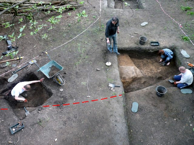
Excavations at the Rectory (Wigan Hall) site are continuing and it seems that at last the secrets of its historic past are beginning to be revealed. Over the last few months our field team (working at weekends only) has been visiting the site regularly and are now beginning to uncover features dating to the 18th century or even earlier.
The old Frog Lane, which was our original target, is still proving to be elusive, but a well-made cart track, lying under the 19th century garden path, could prove to be its forerunner. With a width of 3.5 metres, it is too narrow to be the lane which, on the 1847 OS map, is shown to be 7 metres wide. However to the north side of the track is an area of compacted building rubble which we suspect formed the base for the wider Frog Lane. It was in this area that the water feature was uncovered (report in Newsletter 133). One theory is that the water feature is a drain, in which case it could be the only evidence left of the old lane which was dismantled when the grounds were extended in 1875.
On the 1847 OS map the old lane is shown turning into Hallgate as it gets nearer to the entrance to the Hall grounds. Our test pit in this area confirms that the cart track follows this same line (indicated in red). This convinces us that the track, even if not the original road, was its foundation. The construction of the track found in the test pit, however, is different, being made of building rubble set in mortar. This change is probably due to the fact that at this point, the road runs over pit or ditch which has been filled with ash and soft clayey soil (the soil has actually subsided under the road creating a void).
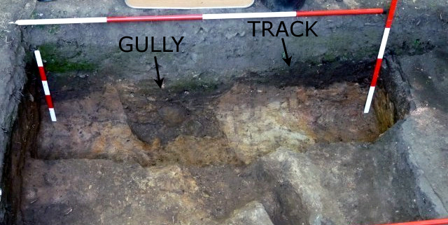
The dirt track, on the other hand, is lying on compacted clayey sand which appears at first glance to be natural. However, on closer examination, this turns out, in some places, to be re-deposited material and, in one area, a pit has been cut into it, backfilled with thick clay. Sections through the track in this area show gullies flanking its edges, presumably to take the run-off rainwater. Post-Medieval pottery from the north gully gives some indication to its age. On the other side of the south gully a square-shaped plinth has developed which seems to corresponds to a small building shown on the 1847 OS Map.
It is obvious that the ground in this general area has been greatly disturbed over the years and it may take us a little while longer to unravel its history. Last week we had a visit from professional archaeologist, Chris Healy of Minerva Heritage. He was able to offer his advice and expertise, which was greatly appreciated (but even he was puzzled by our water feature). If you are interested in getting involved in this dig then contact either myself or one of the team at our next meeting (there are also more details on our Forum).
Summer Trip
Our tour of the Hungate site in York on the 15th August has now been booked and soon we will be booking our coach. We are therefore looking for deposits - if have put your name down, please bring or send Ł5 to confirm your booking.
Etruscan Excavations
Fancy doing some archaeology abroad? - then Etruria Nova are offering courses on an Etruscan site in Tuscany in October. Prices are very reasonable and include accommodation in a modern apartment block. Contact me for more details.
Next Meeting
Wednesday 2nd June in the concert room of the Upper Morris Street Working Men's Club (off Greenough Street), starting at 7.30 pm as usual. Our Speaker this month is David Ratledge who will be repeating the marvellous talk he gave in 2006 on the Roman Roads of the North West. David is responsible for creating the Mario website which he did whilst working for Lancashire County Council. The site enables you to view the 1849 6inch OS map overlaid on the modern day map and even aerial photos of the same area (very useful).
Hope to see you there - BA
|