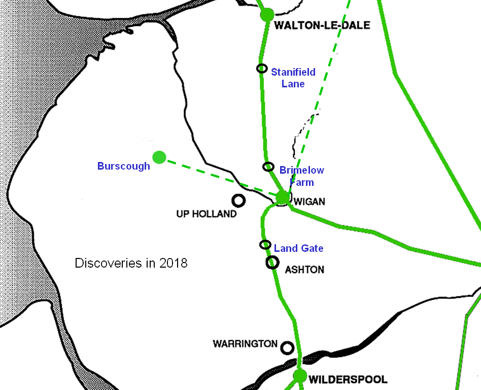
2018 was a fantastic year for Roman Road discoveries. At the beginning of the year a large section was revealed south of Wigan on the road to Warrington at Landgate Farm This was followed by a 10 metre wide stretch north of Wigan running parallel with Stanifield Lane. In the summer we returned to Brimelow Farm to uncover more of the road we’d discovered in 2004. However the greatest excitement was the revelation of a brand new fort at Burscough. With the help of our resistivity survey carried out that year, this site has now been Scheduled (1470328) but this now leaves the question about links to other forts ans settlements round about. Our interest is of course focused on the possible link with our site at Wigan but, due to the restrictions of the Douglas valley, there are a number of possible option. Two High Level Routes.
Ormskirk Road, leading out of Wigan on the south side of the Douglas valley, is favoured by David Ratledge (Roman Roads in Lancashire). The route passes through Pemberton and Up Holland, zig-zagging its way up the hill through the town centre. It would then pass along Ashurst Beacon ridge before dropping down onto Green (Lowes) Lane, through Lathom Park and on towards Burscough. The straightness of Green Lane looks very inviting as a Roman road but there is a problem with it. This lane overlies a landscape feature referred to as The Lines which is undoubtedly associated with Lathom House. This would tend to put some doubt on this route .
Hall Lane on the north side of the Douglas valley, leading through Wrightington is another high level but possibly easier as it could have branched off from the main Roman road north out of Wigan at Standish (Arbour Lane west of the town centre may be the clue to this route). It would have crossed over Parbold and down through Newburgh towards Burscough (in fact the short length of Roman road projecting from the east gate of the fort at Burscough, as detected by our resistivity survey, does point towards Newburgh).
Two Low Level Routes. A more direct route out of Wigan of course would be through the Douglas valley up towards Newburgh, possibly along Dalton Lees on the south side of the River, but this is anything but straight. There is also a possibility it could have gone on the north side of the River below Parbold Hill, following Wood Lane say (building the canal may have destroyed much of the evidence for this route).
All these options I’m sure will be investigated by the Society in the coming months and years.
