
Date: 19th November 2018
This year we’ve spent most of our time on other projects around the Wigan area – including Landgate Farm Roman road, Brimelow Farm Roman road and the new fort site at Burscough. However, having decided to buy a drone this summer, we eventually got round to taking it out for a test flight – and Toddingtons seemed to be the ideal spot. Having figured out how to connect it to my mobile phone we got the thing of the ground quite easily and, despite the windy conditions, we found our drone (the DJI Phantom 3 Standard) remarkably easy to fly – albeit always in beginners mode.
  Present UK regulations restrict drone flying to 400 feet (120m) and not within 50m of built up areas or 150m form crowds. However this gives us plenty scope for our purposes (that is until the end of 2019 when the Government are proposing to introduce licensing and the need to pass an online tutorial).
  Before the end of December last year we finally got digger John to back fill our trenches and as you can see he did a great job. Our two site were on the left hand side of the track in the above image (first between the gorse bushes and second at he bottom of the picture).
Date: 1st December 2017
This must be or last visit before we back fill (in fact we’d arrange for digger John to do it but unfortunately he got called away). Anyway, Andy and I took the opportunity to take up the hard surface in the bottom of Trench 3 in an effort to try to understand the extent of the ditch or shallow depression feature we had detected in the north section. 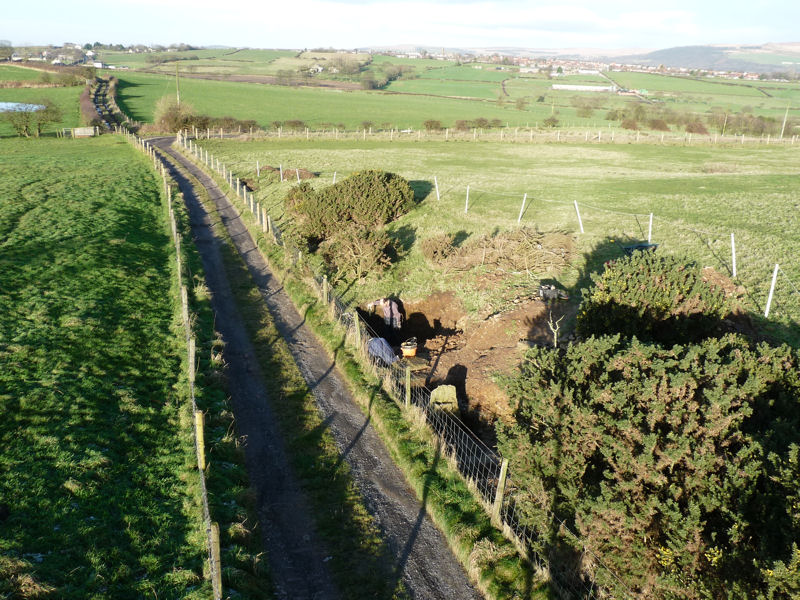 First of all we needed to remove the step we’d left in for ease of access. Due to the recent frost, the top surface came away in on large chunk, revealing a couple of pieces of pottery similar to the piece we had found in the section – confirming this road body material was definitely post-medieval. Similarly the hard surface came up in large chunks but this time, unfortunately, no finds. What it did reveal however was that the fill material of the ditch feature continued everywhere we looked under the hard surface, even in the area of the small post hole where we previously hadn’t detected it.
  This demonstrated that, instead of a ditch feature, the original ground surface must have been very irregular ground and had been leveled before the hard surface as laid. The underlying natural seems to be a stony clay mix – quite soft, not the hard rock or marlstone we had uncovered further down the field.
We think we have gained as much as we can from these trenches now so next week hopefully we’ll be able to get them back filled.
Date: 2nd November 2017
Having been rained off last time, we needed a return visit to record our newly found features in Trenches 1 and 3. We were back to our usual three this week with Patrick back joining Andy and myself. It’s usual to complain about the weather but actually it’s done a great job in cleaning the site for us revealing the road surface in all its glory. Andy and I continued to open up the trench on the south side to see if we could understand what was going on with the stones that make up the wall. This revealed that although the wall does seem to continue at the same with, it’s construction is less robust – more rubble being used and clay to fill in the gaps. The stone on the western side together with the rubble behind it, do appear to be part of the structure but only at the foundation level.
 During the time we’ve been on this site we have seen a wide variety of wild life – beside the usual sheep and horses we’ve had kestrels, jays, oyster catchers and buzzards (a group of nine went over one day). Our latest creature is the tiniest and cutest – a baby newt.
 While we admired the wildlife, Patrick continued cleaning up the ditch feature at the bottom of the section in Trench 3. What he found significant was the smell coming from the black clay deposit which was sulfurous suggesting rotting vegetation – still no finds though which would enable us to date the feature.
Date: 19th October 2017
Just when we thought had finished more features appear (always seems to be when Andy’s digging for some reason). With Andy and myself this week we had Christine joining us. Andy began by expanded the trench at the bottom of the north section in Trench 3 so that it could be drawn up. Meanwhile Chris and I investigated the south end of Trench 1 where the stone wall disappeared under the turf. When Andy had finished his digging and the section cleaned, the new feature emerged – a shallow ditch (or depression) lying under the hard surface.  This new feature was filled with brown gritty clay with pockets of dark grey to black clay with an orangie crust top and bottom. No finds came out of it so difficult to date but certainly not a Roman ditch of any shape or kind. We had detected the same material under the large post hole but strangely not under the small post hole. It would be difficult to determine without undertaking a larger excavation of the area whether it was a ditch travelling at an angle to our trench or whether it was just a localised depressions. Whichever the case, the hard surface has been laid directly on top of it, thus sealing it.
In Trench 1 meanwhile, Chris and I gradually removed the turf from the south side to see if we could confirm whether the stones on the western edge were part of the wall or not. As we cleaned up the section, it became obvious that these had been laid on top of a layer of a blue-ish clay layer. This had been put down apparently to level the surface of the old road because its camber had become quite significant at this point. As the stones had been laid on top of the blue-ish clay, we can only assume that they are also part of the stone wall. Whether a local buttress or something more substantial, we would only be able to tell with further excavations. To add to our problems the weather men got it wrong and, just as we were beginning to draw up the section in Trench 3, the heavens opened. However we did manage to get enough dimensions to start the planning process.
Date: 6th October 2017
We managed to squeeze another day in between late summer hols and the bad weather. Just me and Patrick at first but then Mark joining us around lunch time (first time Andy has missed a session on this site). After scanning our spoil heaps with his metal detector (no finds) Mark spent the rest of his time opening up the hole we started in the bottom of Trench 3 on our last visit.  It certainly enabled us to examine in more detail the layers underneath the hard surface (which although this hard surface was difficult to penetrate, it was surprisingly thin). A couple of pieces of canal coal coming out of the hard surface may give us an indication of its age.
 The dark clay layer, as mentioned before, appears in localised patches with what appears to be a thin crust of orange coloured iron pan lining it both top and bottom. Below the dark clay it looks like we have eventually reached the natural which is a light brown sandy clay (the same material lies at the base of the second posthole).
  While this work progressed Patrick and I continued developing Trench 1. Patrick began removing the blocks of the stone wall while I extended the area in front of the upright stone. This revealed the edge of the road surface on the west side which appeared to have no curbing or revetment, although a short camber could be detected. The cut in the road surface for the upright stone on the wall side was also revealed which seem to confirm what we had suspected in the section.
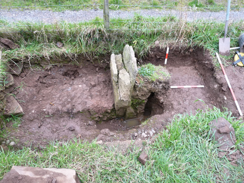
Date: 6th September 2017
Just our usual three today – but with Autumn on the horizon thought we’d better get some days in before the weather starts to turn. First job was to hack through the hard layer around the first posthole to expose the dark clay layer underneath. This proved quite difficult but revealed that the dark clay layer was localised to the area in front of the posthole. The layer underneath it seemed this time to be certainly natural. Also there was certainly no dark clay layer under the second posthole.
We are feeling now that we are reaching the end of what we can discover in these trenches. However we still have the cavity in front of the upright stone to understand and also the extent of the hole cut for it. We therefore extended the section down the side of the upright stone. This revealed the cavity to be circular in section and about half a metre long but there was nothing inside to suggest what had created it. If it was a post it had completely rotted away. Exposing the old road around the front of the upright stone enabled us to determine the extent of the hole cut through it for the stone (at some point we will need to remove one or two of the stones from the wall behind the upright stone to see the extent of the hole in that area as well).
Date: 2nd September 2017
Three of us again but with Ian Paget instead of Patrick joining Andy and myself. Spent most of the time cleaning the hard surface around our new-found posthole at the bottom of Trench 3. This was so that we could draw them up before we hacked into the hard surface to see what was underneath. When cleaned the second posthole turned out to be bigger than we originally thought and rectangular in shape. Still smaller than the first and strangely without any packing stones. It seems too close to the first to be another fence post – could it be a support for it? A half section would reveal more (we had already done one in the first posthole which had revealed the dark grey clay layer under the hard stone surface).
 In the afternoon we made a start on expanding Trench 1 northwards from the upright stone. This was to explore the extent of the hole cut through the road for the upright stone.
  A few weeks ago, whilst trying to put in our datum line on the inner edge of the upright stone, we had discovered a cavity just in front of it.
  It seemed circular and went down about 30cm. Could it be another posthole? but if so, it cannot be related to the others as it protrudes well above the old road surface which buries the other postholes. A half section will hopefully clear up the mystery and also help us determine the size of the hole cut for the upright stone.
Date: 30th August 2017
Back to our ‘Last of the Summer Wine’ three – Andy, Patrick and myself (I’ll leave it to the imagination who’s who but just to say Patrick did have his sergeant major’s outfit on). This week it was time to turn our attention back to Trench 3 where, in early July, we had discovered a posthole punching through what we thought was the natural bedrock. A layer of greyish clay underneath proved that this was not the case – a new layey of archaeology was lurking underneath. Our first job therefore was to clear the area around the posthole to establish its extent – not easy as it was buried under almost the full 0.5m depth of old road material. A thin layer of sand seemingly separates this from the hard surface underneath so easy enough to establish once the overburden had been removed. However as we progressed southwards, lo and behold another post hole turned up less than a metre away. This time not as big but the remains of the post was certainly in there. No dating evidence as yet but a good section through this layer may proved it – something for next time.
Date: 22nd August 2017
Four this week – Andy, Patrick, Mark and myself. We’ve that we’ve probably gone as far as we can with Trench 2 (i.e. the collection of Test Pits 1 to 6) but before leaving this area we needed to record all the features uncovered. To do this we first needed to establish a datum line which would enable us to relate this area with the trenches we dug further up the hill. The datum selected stretched from the west side of Test Pit 1 all the way to the east side of the upright stone. From this line we were able to record dimensions of the ditch feature and also the profile of the adjacent lane.
Another loose end needing to be bottomed was the re-cut in our ditch feature which seems to get bigger as we move northwards. A section on the south edge of Test Pit 6 would seem to be able to give the answer. Also opening up Test Pit 6 a bit more would also give us the opportunity to re-establish the relationship between the modern tile surface and the compact stones we’d found in it. The results showed that the re-cut continued to widen and also a new layer appeared lying between compact stone and the fill of the re-cut. It consisted of dark grey sediment about 5 cm thick – difficult to see in the photo but duly record on the section drawing together with the rest of the features. We also took the opportunity to record the heights of the ditch feature along its length and also the modern tile surface in all test pits. This showed only a 30cm difference between Test Pit 6 and Test Tip 4 which is 15m away to the south, seemingly to confirm the theory that this whole area was leveled prior to the laying of the modern surface in the late 60’s early 70’s.
Date: 16th August 2017
Good turnout this week – with our usual three Andy, Patrick and myself being we were joined by Mark and later by Lee and his partner Pip. The main job was to clear out the ditch feature so that its profile over the length we uncovered would be confirmed as predicted i.e. gradually getting shallower towards the south until it disappears altogether just before reaching Test Pit 5. This was more or less confirmed despite the edges being not particularly well defined. Another pipe stem recovered from the fill added to the conviction that the ditch is not older than post medieval. We were however able to better understand the secondary re-cut on the west side which, once cleared out, appeared to disappear after about 1 metre after leaving Test Pit 1.
 Before clearing out the ditch we Andy and I took the opportunity to draw up the south section in Test Pit 1. We have still no idea what the purpose of this double ditch system was. One reason perhaps though for its disappearance the further south we go however, could be as a result of leveling carried out when the modern tile surface was laid in late 60’s or early 70’s.
Date: 10th August 2017
With Patrick back from his Orkney Saga we had four again on site this week, including myself and Andy with Dave North joining later on. Being quite convinced that our ditch feature in Test Pit 1 does not appear in Test Pit 5 (3.0m south of it), we needed find out why. Could it lead to some other feature or perhaps turn off in another direction (which would certainly be interesting). Some effort has gone into making this ditch so there must have been a good reason for it.
The only way to find out, it would seem, would be to chase it ‘from the know to the unknown’. This unfortunately meant moving our spoil heap (but if we did it in stages it would hopefully avoid us wasting time and energy if the end of it appeared early). However, as sod’s law dictates, we had to dig the whole lot out – all the way to Test Pit 5. The end of the ditch feature, when it came, was quite subtle and difficult to see. It seems that the ditch feature just peters out, rather than terminating abruptly. Ah well, at least we know now why it’s not seen in Test Pit 5. Think we’ve finished here now, however still need to do a half-section of the ditch just to confirm its profile before we leave it.
Date: 6th August 2017
Four on site today, as usual me and Andy but, as it was Sunday, joined later by Ashley and her partner Chris. During the week Ashley is on secondment to a site near Oxford from Liverpool University, working (for money) excavating and recording Iron Age features . She was able to give us the benefit of her very valuable experience, particularly with the post hole feature we had discovered in Trench 3 a few weeks ago.
In Trench 2 – Test Pit 1 the weather has been kind to us, cleaning the natural marlstone bedrock to show up our ditch feature quite distinctly. In Fact in the north section the re-cut is very distinct with a completely different fill material.
 Ashley’s advice was that we should record it and empty it out on the north side towards Test Pit 6 where we had found the compacted stone layer. This proved to be quite an easy task and as we reached Test Pit 6 it was obvious why we could not detect the ditch feature as it continued underneath the stone layer.
 This was good news as it meant the rock-cut ditch was not just a local feature – the bad news however was that a couple of pipe stems came out of it, making it fairly certain that it was post-medieval in date (anything older would have filled up well before the pipes stems arrived).
Slightly dismayed we decided to have another look at Test Pit 5 on the other side of Test Pit 1 to see if digging deeper we could find the ditch in that direction. After some hacking away we had to come to the conclusion that all we had here was bedrock, so we still have a mystery – what happens to the ditch going south. Unfortunately extending the trench in this direct will mean removing out spoil heap but seems necessary if we stand any chance of understanding what was the purpose of this enigmatic ditch feature.
Date: 19th July 2017
Down to just two of us today, myself and Andy (with Patrick visiting late on to catch up on developments). As mentioned last time we needed to extend Test Pit 1 to see what happens to the ditch feature as doesn’t appear in either Test Pit 5 or 6. Working northwards, a 1 x 1 metre extension was cut in the turf revealing as usual the modern tile material. After removing this, the ditch feature was revealed but strangely where we expected the natural rock on the east side, a thin layer of compacted stone appeared (similar to the stony layer detected on the west side) – could this be the remnant of the post-medieval road uncovered in Trenches 1 and 3? Also it became clear the reason why we couldn’t see the ditch in Test Pit 6 as the ditch fill stops just before it, replaced by the stony layer covering the rest of the trench. The question now is whether the ditch finishes at this point or the stony layer replaces the fill (a mystery hopefully we can solve next time).
We’d also arranged with digger John to come and back-fill Test Pit 3 as the area on the east side, where we had removed the modern tile material, had revealed bedrock which gave us confidence there was nothing more to find in this trench. Just in case however, before the digger arrived, we decided to just check the west side with a small cut 60cm x 45cm.  This proved to be particularly difficult as the modern material had been very well compacted (or even concreted in) and about 15cm deep. However once again only bedrock lay underneath.
Date: 15th July
This week we chose Saturday for our site visit to give our weekend diggers a chance to get involved. This meant we had Ian Paget (a GM volunteer) and Darren with us – and Christine came later her brother (but just to visit).
With the extra manpower we looked to see if we could make some progress in two areas. Last time in Trench 3 we had discovered a post hole and Patrick and Andy was given the job of clearing the area around it to see how big it was. This was no mean task as there was a large amount of material to shift – compounded by the difficulty of getting the spoil out of the trench. A ramp was attempted for the wheel barrow but in the end buckets seemed to be the easiest way.
The other puzzling feature we need to sort out is the rock-cut ditch in Test Pit 1. Our previous work had detected a double ditch in the south section but this had not been detected in the north section. Also a possible second stony layer could be detected under the modern tiles on the side next to the fence. As we cleaned up the north section however, what appeared to be a re-cut, did begin to appear on the west side – wider than the one we had detected on the south side. Also last time we had opened up another test pit (Test Pit 5) 3.0m south of Test Pit 1 to see if we could pick up the line of the ditch feature. This revealed the same modern surface underneath the turf as expected but underneath that was hard compact stony surface – certainly not the soft material of the ditch feature in Test Pit 1. We therefore decided to open another test pit (Test Pit 6) on the north side of Test Pit 1 one metre away. This once again produced a hard compact layer of stone under the modern material.
  We are still struggling to understand what is going on with the ditch feature – the only thing to do therefore is to extend Test Pit 1 and follow the feature to see what’s happening to it – a job for next time
Date: 12th July 2017
Again just three of us today but with Patrick instead of Lee (Lee did visit in the afternoon with couple of his friends who seemed to be very impressed with our activities). The intention of this visit was to expose more of the bedrock in Trench 3, which Lee had come across on our GM Festival day, just to confirm that this was what it was. Patrick set about with this task while Andy had a look at deepening our new test pit, Test Pit 4. On our GM Festival Day Ian had discovered the modern road surface about 40cm down. Before closing down the test pit we thought we should see what lies underneath. The result seemed to be more bedrock material – so I asked Andy to open up another test pit, Test Pit 5, 3.0 metres south of Test Pit 1 just to see if we could pick up the line of the ditch feature we had discovered in it.
Meanwhile Patrick was busy extending the base of Tench 3 while I cleaned and recorded the road surface in this trench (which is looking quite impressive but we know it can only be post-Medieval). As Patrick progressed exposing the bedrock surface he came across what appeared to be a post hole buried in the road material complete with packing stones around it. The fill consisted of very black humus material which could be the remains of the rotted post. In plan the section through the ‘post’ appeared to be a quadrant as if it was the quarter of a split log.
 I asked Patrick to do a half section so that we could see what it was like in profile – but as he dug around it, it was obvious the ‘post’ had been set in a hole cut into the bedrock. As we dug this out however, we came across another layer of soft grey clay material appearing to lie under the bedrock.
 This took us by surprise as it means this isn’t bedrock but another surface (which is what Patrick had thought as he was cleaning it). We must now cut though this layer to confirm this and who may know what else we might find – a task for another day.
Date: 4th July 2017
Just three of us today, me and Andy with Lee joining us in the afternoon. Before we started I presented Mrs Pendlebury with copies of the original Haigh Estate map of 1796 which I had been able to get from the Wigan Archives at Leigh. It confirmed that the version we had come across in May was just a tracing, however the details had been correct. Mrs Pendlebury was very pleased with this but wanted to know when we were going to announce that we had found the Roman road. We had to confess that we hadn’t found it yet – the old road discovered in Trenches 1 and 3 could not be older than post medieval and there didn’t appear to be anything earlier than the modern surviving in the test pits of Trench 2. However we were able to reassure her that we hadn’t totally given up hope and gave her the age-old response ‘lack of evidence in not evidence of lack’.
One thing we did need to do was to record the newly discovered natural rock surfaces we had discovered last time. With all the rain we had had since our last visit I expected the Test Pit 3 extension to be like a swimming pool. With this in mind I had brought our old water pump but as it turned out the drainage must have been quite good as there was only a small amount of water in the bottom which was soon cleared with a bucket and sponge.
The rest of the morning was spent extending Test Pit 1 slightly (to the west and south) and removing the modern surface so that we could get a better look at the natural surface underneath. It would also hopefully expose the line of the ditch feature we had discovered in this test pit. When finished (carefully avoiding the blue water pipe) we ended up with a trench 1.1 metres wide by 1.9 metres long. Unfortunately the line of the ditch feature did not show up very well in photograph but in the section it can be seen quite clearly. In fact there appears to be a second shallower ditch on the fence side (although this could not be detected in the opposite section).
 This ditch is still unexplained, however on the fence side there does appear to be a second layer of stone lying under the modern surface. Being so close to the fence this is going to be difficult to investigate. It would therefore be beneficial, at some point, if we could open a trench on the opposite side of the track (maybe clutching at straws but another ditch on the other side would certainly give us somthing to think about).
In the afternoon Lee help to expand and clean the area of natural rock in the Test Pit 3 extension which we had uncovered in our last visit. This proved quite difficult as the modern tile material was firmly embedded in the underlying stone and clay. In the end we contented ourselves with a 0.5 metre by 2.0 metre cut through the modern surface to the rock below. This confirmed that there was no earlier road phase in this area (or, if there had been, it had been destroyed prior to the new road being laid).
 The underlying surface is not solid rock but a mix of stone and clay very well compacted to the extent that our pick axe just bounced off.
Date: 22nd-23rd June 2017
This week end was the GM Archaeological Festival which for us involved inviting volunteers to come and help us with our excavations. Over the two days we had a total of six joining us, including Julie and her partner Paul and Lee on Friday, Vanessa and her son, Lucas, and Ian on Saturday (Lee coming on both days). Helping us on the first day was Ashley, Patrick, Andy and Christine. It was a great success as all seemed to enjoy it, despite the damp conditions on Friday, and hopefully it will result in some new members. Having shown everybody around the site and explaining what we were doing, the first thing we needed to do was to clean up the surface in the newly opened extension in Test Pit 3. This task was given to Julie and Paul, Julie toweling while Paul squared of the end. This took quite some time and seemed to reveal a layer of blackish clay sediment overlaying the surface on the east side, as if this area had been flooded over a period of time. When cleaning was completed, Julie and Paul was able to undertake a height survey along all 3 test pits and out as far as the current track.
 This showed that, despite appearances, the surface from west side of the track to the east side of the Test Pit 3 extension (a distance of 12 metres), was level – for the most part anyway, just dipping down about 20 cm over the last 3 metres on the east side. The surface consisted of modern tiling with bits of coloured plaster together with other modern rubbish such as bits of plastic. The reason for this is still unexplained as nobody seems to remember the field here ever being open. Interestingly while cutting the step for the trench, Patrick came across bits of a broken bottle with writing on (saying CHORLEY and ST HELENS). As it happens the landlord of the Patricks local in Aspull, the Victoria, has a huge collection of bottles (many on display) and was able to date Patick’s bits to turn of the century (not that this helped us as it was found near the top of the trench).
 While this work continued Christine and Andy began cutting through the stony layer in Test Pit 1. This proved to be very difficult and not much progress could be made. This added more weight to the conviction that, despite its mix of stone lumps and hard clay, this layer was in fact natural. Lee in the meantime spent sometime cleaning up the wall in trench one ready for photograph. As it happens Lee has expertise in photogrammetry which is a process enabling dozens of photos taken from different angles to be stitched together to form a 3D view of the object. He said our wall with its end stone would make an ideal subject when we had finished excavating.
On the second day, Ian and Andy were tasked with cutting through the modern surface in the Test Pit 3 extension, while Ian looked at squaring off the cut in Test Pit 1’s stony layer. Andy had actually been able to get hold of bore data from the Wigan Coal Co., for Freezeland farm dated to 1937. It indicated that just under the surface there was a layer of Marl which was over 3.5 metres thick. Marl is a lime rich clay and Marlstone is a type of limestone hich is found embedded in it. Andy had brought some vinegar with him which he had been told would fizzle when applied to the stone if it was Marlstone. This seemed to confirm that the stony layer under the modern surface was in fact a mix of natural Marl and Marlstone.
Meanwhile Vanessa, with her 6 year old son, Lucas, was given the job of preparing Trench 2 ready for recording, which involved cleaning the section and troweling the stony surface. With extra help on hand, Lee and Ashley were tasked to extend Trench 1 with a view to finding the bottom of our upright stone and identifying the original hole required to install it. By the lunchtime, Lee and Andy’s work, cutting through the modern surface in the Test Pit 3 extension, had revealed a new surface lying just below it. This seemed to be natural rock and stretched for at least 2 metres from the eastern most edge of the trench. This was disappointing as it seemed to show that, as with the result from Test Pit 1, there was no other earlier phase of road in this area. Rather than waste more time here in was decided to see if we could pick up the old road further up the hill towards the Trench 2 (where at least we knew we had it). Andy and Ian were therefore tasked with opening a new trench, Test Pit 4 about 13 metres from Test Pit 1.
 At first it seemed that there was nothing in this but loose stone debris mixed in with the top soil – but eventually, at a bout 20 cm below where it was expected, the road surface began to appear. Again though, disappointingly this turned out to be made up of the same modern material as the other test pits.
Meanwhile Lee was tasked with cutting through the bottom of the side section in Trench 3 which consisted of sandy clay marking base of the thick stony layer. Lee soon came upon a hard compacted stony layer which he could not penetrate and looking very much like the natural bedrock we have found in Tench 2. This marked the end of our work here – interesting to note the thickening band of soil on the west side. This could represent a bank which had built up on the the restricted road. Despite all the setbacks we had made some progress and at least our volunteers got to do some real archaeology and seemed like they thoroughly enjoyed themselves.
Date: 14th-15th June 2017
Two days on the trot this week (as not everybody could make it on the same day) – Wednesday we had Ashley, Andy and myself with Patrick joining late on and Thursday Christine came down with me and Patrick. A bit of work to do as we needed to prepare for next week’s GM Festival when guest volunteers will be joining us – 3 on Friday and 5 on Saturday.
Test Pit 3 was half full of water so I bailed that out while Andy and Ashley worked on Test Pit 1. The section we had opened up last time revealed two different materials under the modern tile surface. On the west side was fairly soft gritty sandy material but on the east side it very hard compacted stone with hard clay. It was difficult for us to ascertain whether this was natural our an earlier deposit. As we cleaned up the section it became obvious we had a shallow ditch cut into the stony layer which had been filled and the modern tile and plaster material laid on top. There were no finds in the ditch apart from some charcoal or partially burnt coal in the bottom. However and interesting find did come out of the stony layer, albeit no helping us with dating the deposit. We’re reckoning it to be about 300 million years old – the fossil of an ancient plant, i.e. the stem of a calamite which is a sort of giant horsetail.
We extended the trench a spade’s width towards the fence (this was as much as we could go) to see if the hard material returned on this side. It did but not quite to the same height on the other side. This ditch is looking very Roman like but it’s in the wrong place and the stony layer should not be on both sides. Obviously more work to be done in this trench to confirm or otherwise if the hard stony layer is natural not.
Our other issue here is how far does the road surface extended. With this in mind we had arranged with the farmer to get ‘digger John’ to extend test pit 3 a few more metres hopefully till a surface edge could be detected. It was late in the afternoon when he arrived and, as he steadily began to extend test pit 3 east wards, we realised how grateful we were for the use of the digger as the trench was now getting to be over a metre deep. As it progressed eastwards more and more building rubble began to appear in the trench making it clear that this landscape had been created in a single event. However, on close inspection, the road surface continued albeit seeming to dip down the further east we went. Eventually, after creating a trench 4 metres long and with no sign of the edge, we decided to stop and leave closer examination for the next day.On the following day we concentrated on preparing the trench for next weekend’s GM Festival of Archaeology. For our contribution to it, we have invited up to 6 volunteers from the general public to come and help us over the two days with our excavations.
We started by cleaning up the extended Test Pit 3 which confirmed that the road surface had the modern tile material (see below) all the way from one to the other with finding modern plastic artifacts embedded in its surface (this was at 1 metre down).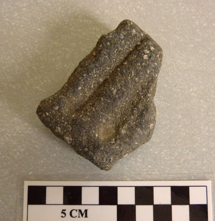 We also needed to make Trench 3 more stable as the digger had left the spoil right on the edge of the trench (this was inevitable due to the restricted access). This was probably when we discovered our most significant piece of evidence yet. In the section of Trench 3 lying well down in the stony layer was a sherd of orangey-red pottery –
 – not Roman unfortunately as it had a dark brown glaze on on side.
 This proves fairly conclusively that the stony road surfaces in Trench 3 and Trench 1 can’t be older than the 17th or 18th century.
Date: 2nd June 2017
Slow start this week due to the weather but a good turn out again including Ashley and her partner Chris and Christine (in her wellies) making up the numbers with myself and the ever-loyal Andy. By lunchtime the rain was supposed to stop but the intermittent drizzle persisted through the afternoon. However we were determined to make progress so Ashley and Christine set about expanding Trench 3 on the south side while Chris deepened the section exposed on the north side.  A change from compacted stone to sandy clay at a depth of 1 metre on the west side suggested he had reached natural (although this was far from certain). However it did give us the opportunity to take level readings with the dumpy level. This showed that the cobble surface was more or less level across the 2 metre width of the trench and, significantly, also level with the cobble surface of the current track. This strongly suggests they are one and the same thing.
Meanwhile Andy and myself had tasked ourselves with expanding test pit 1 in preparation for sectioning.This showed a continuation of the surface made up of broken roofing tiles and what now appears to be coloured wall plaster (proving that our assumption last week that it was a local repair was wrong).  Once the surface had been recorded, we began expanding the section we had began last week. This proved quite difficult as the stony layer underneath was very compacted and we began to wonder if it was actually the natural rock. Something to investigate next time.
Date:23rd May 2017
Good turnout this week with the addition of Ashley Brogan, Dave North and later Mark Tildesley with his new hand-held metal detector (still no finds though). With the extra resource we decided to open a third test pit (TP3) two metres to the east of TP2 to see if we could find the edge of the flat surface discovered in test pits 1 and 2.  This time we didn’t come across the same debris level as in TP2 but there were still large pieces of stone loose in the soil which took some while to get through. Eventually though, the flat surface was reached at a depth of around 80 cm. It seem to consist of the same tile material as the other two rest pits and a quick depth check with the dumpy level confirmed that it was at the same height as well.
  We also decided to cut through the surface in TP1 to see how deep the tile material was and what lay beneath. We found that the surface was very shallow lying on a compacted bed of dirt which was surprising. However this seemed to be the fill of a shallow ditch cut into a stony layer. To confirm the extent of the stony layer, we extended half of TP1 eastwards which showed that this layer reach the same level as the tile material, suggesting that the tile material was just a local repair.
  In the meantime John, Mrs Pendlebury son and the farmer at Toddingtons, had arranged for a mechanical digger to help us clear the gorse from the area just to the north of Trench 1 and also open up another trench, Trench 3, to see if there was an opposing gate post and wall.
 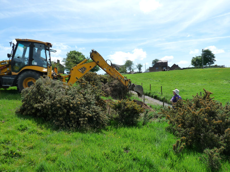 The map had indicated a 4-5 metre gap but there was no sign of a wall. However in the section cut by the digger, the soil horizon could clearly be seen indicating the origin level of the field.
 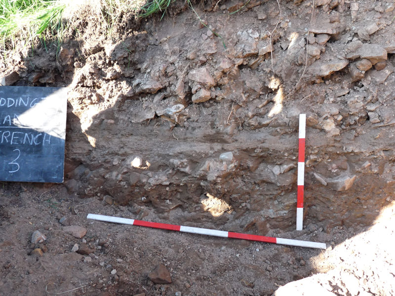 Also underneath this we could clearly detect the stony layer of the 18th century road. Opening up the trench to the south we soon were able to expose a larger area of this cobbled surface.
  To prove that this surface was any older than the 18th century however, we need to expose the edge which would still prove very difficult in this area even with the digger due to the depth overlying stone debris.
Date:17th May 2017
Just the three of us again today but enough to carry out the necessary surveying with the theodolite so that all trenches and test pits could be planned in accurately. We were also able to carry on opening up test pit 2 which we had started last time.  We soon we’re able to show that the stony debris spread across the whole of the trench (with a large lump of tar like material on the east side which proved impossible to remove).
  Once photographed and recorded we cut through the stony debris and soon came onto a flat surface lying under the stony overburden at a depth of between 35 and 50 cm. It comprised of very similar material to test pit one and obviously a continuation of this surface.
  For a few weeks now we’ve been digitising all the various maps so that we can understand the development of the area over time. Adding the accurate survey data enables us to see exactly where our trenches are located relative to the previous road alignments.
  The result shows quit clearly that the access road to Freezelands Farm in the 18th century started not far from Trench 1 where we discovered the stone wall with its terminal stone (could it be the entrance gate). It also shows that our test pits are well inside the with of the original road which is shown as almost 13 metres wide at this point. To have a chance of revealing the road edge, which may give us a clue to its construction date, we would need to go much further out with our next test pit.
Date: 9th May 2017
Only three of us this week (Chris can’t make Tuesdays) – anyway we were determined to open up another trench further down the hill to see if the road we had discovered in our first trench had survived elsewhere – and if so, could we determine it’s age. We therefore started with two tests about half way between our first trench and the track leading to Freezelands Farm. Sure enough in our first test pit we came across a surface lying just under the topsoil (about 12 cm down). However it wasn’t made of the same material as the road further up the hill. This one was made of some sort of reused building material reminiscent of broken roof tiles of various colours ranging from light brown to black similar to the ones used to repair the current track.
 The fabric of pieces were all very similar, i.e. with small quartz inclusions, mainly flat and about 12 mm thick but some were moulded into a curve shape. Many were smooth on one or two sides and some look like they had surface paint – red, green and black.
 The conclusion is that is a road repair but when? The material suggests mid 20th century but neither Mrs Pendlebury nor the Farmer at Freezelands remember the track being any wider than it is now. We would need to cut through this to see what was left of the original road. However we first decided to open up a second test pit a metre to the east to see if we could find the extent of it. In this trench however we immediately came across the quarry debris similar to what we had been finding in our initial excavations further up the hill.
 Hopefully we’ll find our road surface surviving underneath – a task for next time.
While Patrick and Andy where digging the test pits, I went back to our first trench to see if I could find the bottom of our ‘milestone’ and get a section drawing of the wall. I managed to establish the cut which had been made through the road for the upright stone but still couldn’t get to the bottom of it. What is significant however, is that it seems like the cut did not go beyond the wall. It is as if the wall had been built first then the hole dug for the end stone (without disturbing the foundation on which it was built i.e. the road). If this is the case, the the road at this point survives to quite a depth (which very similar to how Roman roads were constructed – it isn’t proof but doesn’t disprove it either and bodes well for further investigations).
Date: 4th May 2017
Back to our usual four today (myself, Andy, Patrick and Chris) and couple of significant developments. Firstly we’ve come across an estate map of the area dating to the late 18th century which shows Riley Lane and Meadow Pit Lane as proposed new roads. This proves that Toddington Lane was the original main road towards Blackrod and Adlington.  It also shows a track leading off across Great Stone Pit Hey towards Freezelands, a farm just a few hundred yards to the northeast of Toddingtons. This however was not in the place where it is now but further up the hill roughly where we are digging. Could our gateway be the entrance to this rack? (Patrick was already question why the current track didn’t taken the shortest route across the field – perhaps it had to be moved to its current location to avoid the quarrying operations).
Secondly, as we cut through the rubble to establish a section to show the band of dark soil, we noticed the stones were different than the general sandstone blocks which defines the general rubble. These stones directly under the soil band were pale blueish in colour and smoothed on top. It was obvious that this was another surface and, in fact, was what the stone wall was built on. With a bit of effort (due to the depth of the trench) we extended the trench eastward to see if the stone surface extended beyond the area of the stone wall. Sure enough the stone surface was seen to continue as far as our trench would extend.
 The only explanation for this surface is that it is the road surface shown on the 1849 map – proving the 19th map makers were correct when they showed that Toddington Lane as a broad road (broad enough to be Roman). The next question is – is it Roman? The only way to answer this would be to open up a larger section to see if it was a typical Roman road section with ditches on each side. It seemed obvious we couldn’t achieve this in this trench (without mechanical help anyway) but perhaps it was possible further down the field where the slope is more gentle. This we would have to leave til our next visit.
Date: 20th April 2017
No Chris to day but Mark brought his metal detector to check out the spoil heap (needless to say he didn’t find anything). We started off by measuring in the position of the stone and the surrounding features so that we could draw an accurate plan. However we were distracted by Mrs Pendlebury who wanted to discuss our findings with her. We presented her with the 1893 OS map which has the bridge over old colliery railway line which ran through the quarry at the top of the hill.  Mrs Pendlebury remembers it well and reminisced about playing in the quarry as a child. It was only filled in 40 years ago when the bridge was removed (there is nothing to indicate our stone feature which is located roughly where the n of Lane is). However we also showed her an overlay of the 1849 map which clearly shows the quarry further down the hill.
  This is right where our stone and wall is located and therefore it seems quite possible that the wall is associated with the quarrying activity. Maybe it was there to stop people falling into the quarry. When we finally got back to digging, we discovered that the wall was built on top of stone debris.
 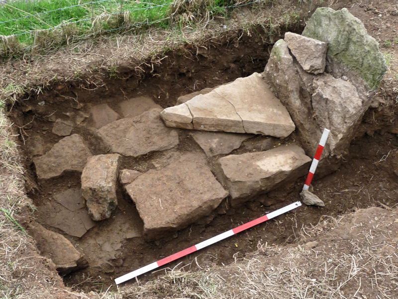 This suggest that it was built part way through the quarrying operations. The whole area must have been back filled and grassed over as the operations moved up hill (Mrs Pendlebury remembers nothing of it). Looking more closely at the maps, we notice that the Lane is on slightly different alignment and much wider than the present day track. This could be cartographers licence, but the width would fit with the Roman road theory. Investigating further just here may not prove fruitful as the whole area will have been disturbed by quarrying. It is suggested there that a trench further down the hill would be better near where the well is shown.
Date: 13th April 2017
Same team as last week but this time joined with Mark and his help in opening up the excavation around the stone was much appreciated. As we extended our trench we began to appreciate the delicate nature of the stone as bits of it became loose and drop off. It was obvious we needed to retain a bulk of earth against the north face to prevent the whole of the top section from breaking away.  As we extended the trench to the south, large stone blocks started to appear which seem to butt up against the stone on the south side of it, and thus, the true nature of the stone began to become clear. It seems quite obvious that what we have is the foundations of a dry stone wall and that the stone itself is the terminal end of it.
 Stone debris completely covers the wall suggesting it was robbed of its stone some time ago (well before living memory anyway). Dating evidence from the small selection of pottery suggests 19th century although we did get a piece that looks like it comes from the Tudor period.
 On the east side we could identify a thick band of soil butting up to the blocks indicating that the wall must have stood in use in the open for some time before being abandoned.
Date: 7th April 2017
This, our second visit to the site, consisted of a small team of excavators, Andy, Christine and myself – to be joined later by Patrick. Our intention was to give it a closer inspection and perhaps prepare the site for a larger excavation at a later date. On our first visit, we had established that only a small section protruded above ground, but the larger broken-off piece lay close by.  It wasn’t clear at first which part of the stone the broken-off top section had come from. However on closer inspection we were able to match up the offsets on both pieces. We were also keen to see the underside of the broken-off section to see if there had been an inscription although none had been reported (if it was a milestone one would have been expected). When we turned the stone over however it was apparent that the surface was quite rough suggesting that it hadn’t even been dressed.
Our first job was to clear away the vegetation (main prickle gorse) including a large piece which was growing out of the cracks it the stone. It was obvious that the stone had suffered badly from the roots and also frost damage which had produced deep vertical cracks in it. The ground surrounding the stone consisted of course stone rubble and there was no obvious cut for the stone. As we dug around the stone in-situ, the size of it become much clearer. It was obvious that its original size had been much thicker. It seems likely that sections had broken away from both front and back, leave what was once a 30 cm thick stone, with only a 10 cm wide section sticking out of the ground.
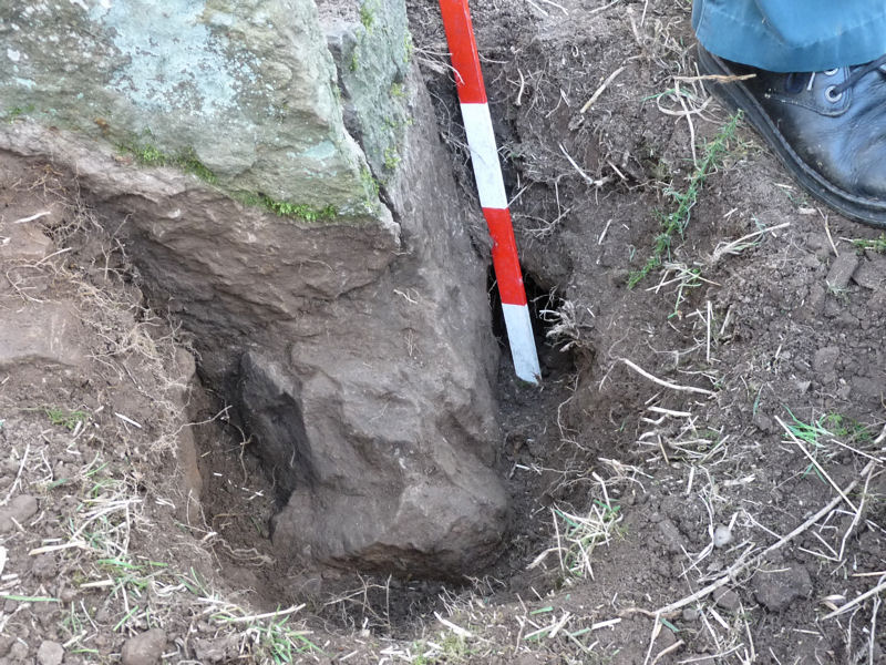 The ground on the road side of the stone appeared to be soft with little stone in it. This was contrasted on the other side with consisted purely of stone rubble fill.
 With no sign of the bottom on either side, it was obvious we would need to open up a much wider area.